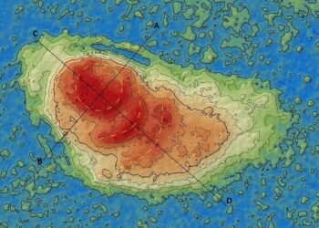
New aerial surveys have uncovered a striking new view of the ancient Mesopotamian city of Lagash—revealing that the city wasn’t a single, continuous sprawl as once thought, but rather a cluster of four marsh islands connected by a network of waterways.
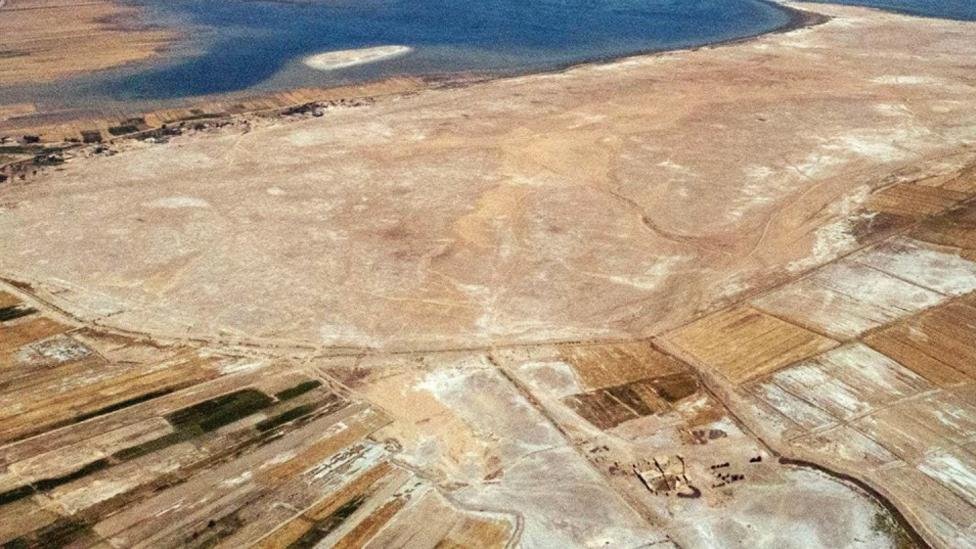
Located in present-day southern Iraq, nestled between the Tigris and Euphrates rivers, Lagash was one of the earliest urban centers in human history. The city emerged around 4,900 to 4,600 years ago and was abandoned roughly 3,600 years ago. Archaeologists began excavating the site, known today as Tell al-Hiba, over four decades ago, but recent technology is offering a much clearer picture of what this ancient city looked like.
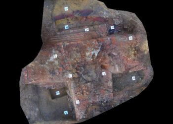
In 2019, researchers used drones to survey the site over a period of six weeks. These low-altitude flights captured detailed images of the landscape—far surpassing what satellites had previously been able to reveal. The drone imagery highlighted outlines of buildings, walls, canals, streets, and other features that had long been hidden beneath the surface.
Anthropological archaeologist Emily Hammer from the University of Pennsylvania led the analysis of the drone data. Her findings suggest that Lagash was primarily composed of four separate islands nestled within a marshy environment, each connected by a network of waterways. This layout upends traditional assumptions about how southern Mesopotamian cities were structured.
“Rather than radiating outward from a central temple or government hub, as we’ve long believed, cities like Lagash seem to have grown as loosely connected sectors,” Hammer explained. “Each marsh island may have developed its own economy and identity.”


Hammer likens this configuration to Venice, where waterways define neighborhoods and each sector plays a unique role. On one of the islands, for example, signs of canal systems suggest a community centered around fishing and harvesting reeds for building materials.
Her findings, published in the December issue of the Journal of Anthropological Archaeology, propose a more complex and decentralized model of early urban development in Mesopotamia. Instead of one cohesive city encircled by a single wall, Lagash appears to have grown through separately developed zones—each with its own infrastructure and purpose.
Further drone analysis identified remnants of harbors and footbridges, indicating that boat travel was essential for moving between the city’s districts. Two of the larger islands were surrounded by walls and contained organized street grids and evidence of kilns—hinting at activities such as pottery production and agriculture. These zones may represent the earliest settled areas of the city, gradually expanding over time.
A smaller, fourth island housed what appears to be a large temple, suggesting it may have served as a spiritual or ceremonial space.
Earlier studies support this evolving picture. Jennifer Pournelle, an anthropologist from the University of South Carolina, had previously shown that cities like Lagash were constructed on elevated mounds within the marshlands. Archaeologist Elizabeth Stone of Stony Brook University used satellite images to identify as many as 33 small marsh islands in the region, adding further weight to the idea that early cities in this area were more fragmented than once believed.
This mosaic-like urban structure would have had significant social and logistical implications. It challenges the long-standing belief in a centralized city model and reinforces the idea that many early cities in southern Mesopotamia were multi-centered, each shaped by its environment and local resources.
As modern technology continues to uncover more about ancient settlements, studies like these are reshaping our understanding of how some of the world’s first cities truly functioned.
More information: Hammer, Emily. (2022). “Multi-centric, Marsh-based Urbanism at the early Mesopotamian city of Lagash (Tell al-Hiba, Iraq).” Journal of Anthropological Archaeology 68: 101458. DOI: 10.1016/j.jaa.2022.101458